iOnTheSky camera footage from 31st August 2017 UT

A screenshot from the iOnTheSky camera footage timelapse movie from 31st August 2017


Hunter Geophysics is currently developing the iOnTheSky aurora-monitoring camera network. Each camera in the network automatically takes a photograph every five minutes and allows Aurora Australis photographers to see what the Aurora Australis, light pollution, and weather conditions are like at any given moment.

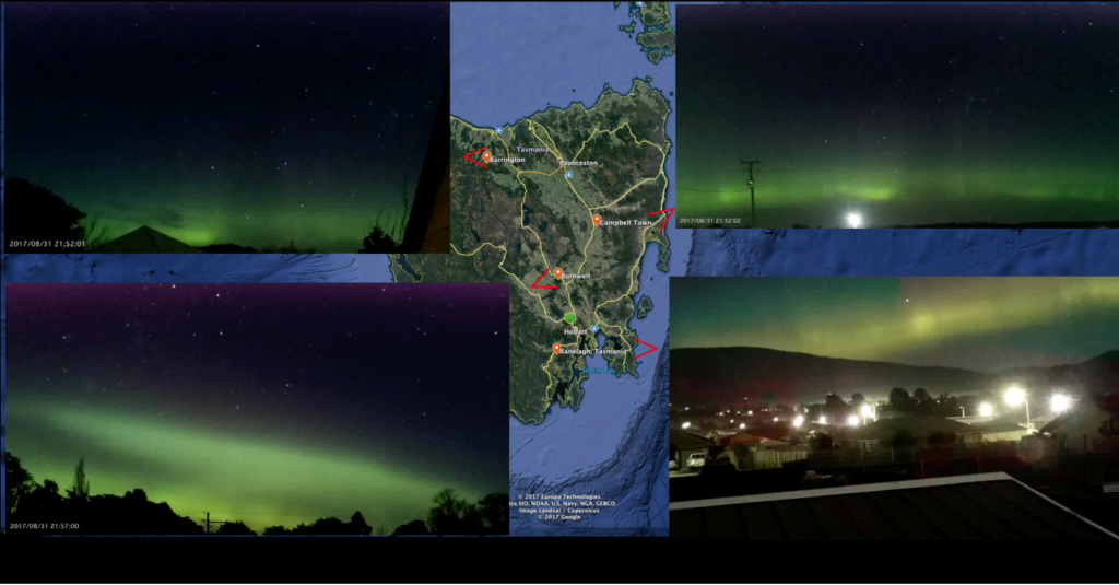
There are currently five cameras installed throughout Tasmania (although one was offline for maintenance on the 31st August). We eventually hope to install dozens of cameras around the world. The footage from these cameras will be made available to the general public via iPhone and Android apps, which will hopefully be released in late 2017.

The below video shows the camera footage from the four operational cameras from 10am 31st August 2017 to 10am 1st September 2017 (from 00:00 to 23:55 on the 31st August 2017, UTC).

The four cameras are situated in Barrington (north Tasmania), Campbell Town (mid-northeast Tasmania), Bothwell (central Tasmania), and Ranelagh (southwest of Hobart, southern Tasmania). The fifth camera (which was offline that day) is based in Abels Bay (slightly further southeast from Ranelagh).


New cemetery services

This month we introduce a new package to our cemetery services: GRAVE HUNTER.

Designed with cemeteries in mind, GRAVE HUNTER is our premiere, fully-integrated electronic cemetery mapping and interment register.

GRAVE HUNTER provides two major capabilities in a reliable, reproducible, and (if desired) publicly accessible electronic format:

  1. Hunter Geophysics surveys a cemetery, taking photographs of every headstone and recording the location of each headstone, generating a map of each headstone. Photographs of each headstone are also accessible via the map (simply by clicking on a grave on the map and selecting to view the photograph).
  2. Details about each burial (such as the individual’s name, date of birth, date of death and any other details found on the headstone) are entered into the map and become an interment register. This register can then be searched electronically, allowing members of the public and cemetery administrators to easily locate a particular person’s grave, or (for example) all burials of those who died in a particular year.

GRAVE HUNTER is, of course, complimented by the proven unmarked grave detection service that Hunter Geophysics provides.

For further details, please see the GRAVE HUNTER page (includes a free demonstration version of GRAVE HUNTER) and the unmarked grave detection page.