Dave the grave Hunter is working in your local cemetery today!
Dave the grave Hunter (his name is actually David Hunter) uses ground-penetrating radar (GPR) to detect unmarked human graves. Thanks to our work, cemeteries can avoid accidentally exhuming unmarked graves when they are excavating for new graves.
You can tap/click on each of the below to reveal more details…
Tell me more about ground-penetrating radar.
GPR works by transmitting radiowaves into the ground and recording the time it takes for them to be reflected by buried objects, much like how sonar works for submarines.
Radiowaves are partially reflected when there is a change in the electrical properties of whatever the radiowaves are travelling through. For instance, if the radiowaves are travelling through a moist soil layer (close to the ground surface), and then go deeper into a slightly dryer soil layer, a small portion of the signal is reflected back to the system (and the rest of the signal continues through into the deeper soil). In this manner, GPR is an excellent tool for detecting variations in soil moisture content. More detail here.
How can ground-penetrating radar be used to find lost graves? Can you see the coffin or bones?
Simply put, when you dig a hole, you create gaps between the soil grains/particles. When you then put that soil back into the hole (after a funeral has taken place), there is a slight difference in the amount of rain water the soil can hold in that area where the hole was dug. This results in areas with differing moisture in the soil. It is these areas of different soil moisture that the GPR detects: we do not directly detect coffins or bones.
It is also worth mentioning that it takes several months of office work to get reliable results from the GPR data. We won’t know where any graves are located when we’re pushing the GPR around.
What does the GPR system look like?
Here’s a short video showing David collecting GPR data in a cemetery:
Do you need to dig? Does the GPR make noise?
No and no.
The GPR system itself is silent. The only noise you might hear is us talking, if you’re close enough.
Ground-penetrating radar is very non-invasive. We don’t do any digging at all. The equipment is pushed around on a small cart (see the video in the above section!). The only things that goes into the ground are four plastic tent pegs (one for each corner of the rectangular search area) and the metal spikes/feet on the tripod of our total station, but these are removed once we finish surveying the area. These generally go in only 1-2 inches deep and leave holes about half an inch in diameter; they aren’t a tripping hazard and most people won’t even know they are there. Once we leave the cemetery, you wouldn’t be able to see where we had been.
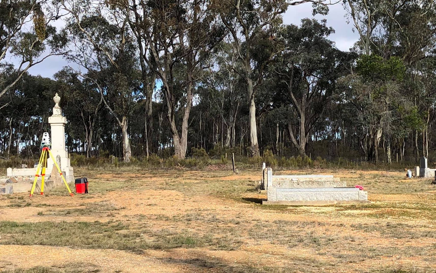
This is our Leica MS60 multistation/laser scanner (a higher-end type of robotic total station) set up among monuments at the Stuart Mill Cemetery:
The robotic total station acts as a laser tracker for the GPR system. The GPR system records radar data every few centimetres along the ground. The total station provides positioning data (northings, eastings, and elevation) to the GPR in real-time so that the position of every set of radar data can be correctly positioned in 3D space. Kinda like a high-end GPS, but with lasers.
How long are you going to be here? How long until you get the results of the survey?
We generally spend a few days in a cemetery collecting GPR data – just walking back and forth with the GPR until we’ve covered the area to be searched. We then head back to our office in Melbourne and spend several months processing the GPR data and interpreting it in order to create a map of any unmarked graves that may be present in the area we searched. Usually, final reports (some examples here) are provided to our clients within three months of completing the on-site data collection work.
What does GPR data look like?
GPR data in its raw form looks like a confusing bunch of squiggly black and white lines (these are known as “radargrams”). Radargrams can be really informative to the experienced geophysicist, but they aren’t intuitive.
Thankfully, radargrams can be compiled into a 3D cube of data, and then that cube can be sliced horizontally. These slices are called time slices or depth slices and provide a plan view of what’s buried at a particular depth across an entire site (sort of like house floor plans, but underground). Here is an example depth slice created based on ground-penetrating radar data collected by Hunter Geophysics in a cemetery:
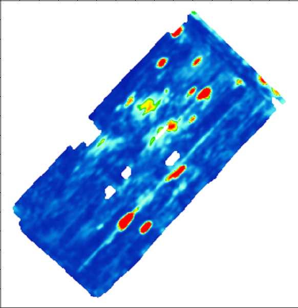
This particular depth slice provides a plan view of features that are buried at about 1.5m below the ground surface. Each red blob is probably an unmarked grave. The dark blue area is undisturbed soil. The lighter blue/yellow areas are slightly disturbed soil, probably due to tree roots.
We usually create these horizontal depth slices at 5cm intervals, up to a maximum depth of about four metres. We can then examine the depth slice at whatever depth we desire (usually we only look at the slices in the upper 2-3 metres, as it’s rare to find a grave more than three metres below the ground surface).
After we’ve created the depth slices, we can create 3D models of the strongest radar reflectors (the red areas in the depth slices). It looks something like this:
This video clearly shows the grave shafts (holes dug into the ground for the graves) in 3D.
Does someone come and put in headstones over the graves you found?
After we provide our client with our consulting report, we come back to the cemetery and mark the graves we found with spray paint. This allows the cemetery to then install more permanent markers. Most of our clients opt to use Besser/concrete bricks sold by our friends at BuildPro.
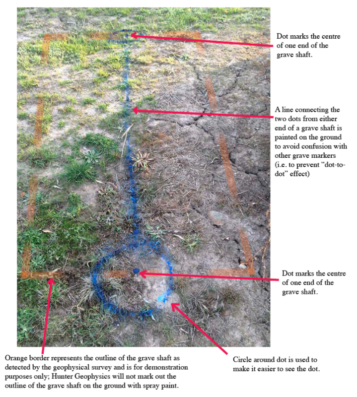
Below is an example of an unmarked grave that has been marked out by Hunter Geophysics using spray paint (in blue). Note the outline of the grave plot (shown below in orange).
Below is a photograph showing how a cemetery placed Besser bricks flush with the ground surface to create a permanent marker for unmarked graves detected by Hunter Geophysics (red lines digitally added to show the layout of the graves).

In Victoria, the majority of our work is funded by state government grants.
More information about our unmarked grave detection service can be found here.